I’ve been checking Google maps every so often to see if they have gotten better satellite photos of certain places like Cuba, NY and a few others. Once in a while they improve and you can actually see most of the country in decent resolution but there is still a bit left to go.
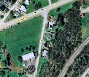
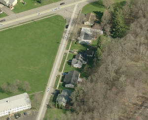
Today I found the new site that has the regular Google images plus it has what they call Birds Eye. It has 4 different views of every place I’ve checked so far including Hill St, Cuba. The images are better than most of the Google ones. Here’s an example
First a pic using the Google satellite image:
And now the Birds Eye view:
Check out some other places. Some are better and some are about the same. I thought it would be interesting to most everyone.


OK, I never get this right. Which one was our house?
If I had to guess, it would be the second from the bottom, since I think we had an attached garage.
Comment by Daryl — Monday June 15, 2009 @ 5:46 pm
I don’t really have any memory of it so I’m no help. You would think I would have gone by there when I stayed with Dale those 2 summers but I was caught up in being a kid.
Comment by Don — Monday June 15, 2009 @ 6:18 pm
You’re right, Daryl. Second from the bottom of the picture.
You’re right, Don. The second picture is much better.
Comment by Donna — Monday June 15, 2009 @ 7:11 pm
I know that there is a little tiny “Fellowship Square” with four or eight units, across the street from our house. I thought it blocked off our view of Main Street, but apparently it is more nearly from the bottom house, which, if you remember, was on a higher elevation.
Comment by Mom — Wednesday June 17, 2009 @ 8:36 am